vTools Survey - GPS Mapping 7.2.9
Free Version
Publisher Description
vTools Survey - GPS Mapping - Field survey and mapping with GPS location
Function of application:
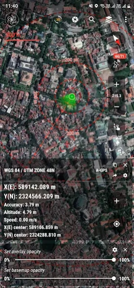
- Positioning, current position, practical view angle in the field. Help identify better directions.
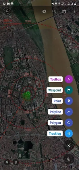
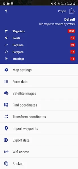
- Allows users to directly create objects (Points, Lines, Polygons, Coordinate Waypoints, Tracklog routes).
- Allows rapid measurement of the area and length of objects in the field.
- Users can simultaneously create Tracklog, Point, Line, and Polygon at the same time while moving. Tracklog mode allows running in the background.
- Support to save attribute information and images in the field.
- Users can define forms fields to collect. And share quickly to the whole group via QR code or export to file.
- Find for waypoint, enter a list of waypoints from data TEXT(*.txt), Excel (*.xls, *.xlsx), CSV (*.csv) Excel and convert point coordinates directly on the device.
- Allow to enter the list of points to check by hand (For example, it is necessary to check the location of the extract of the red book).
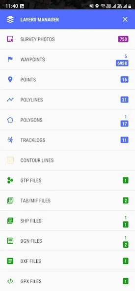
- Support directly opening common data such as Excel, GPS/GPX, KML/KMZ, GeoJSON, AutoCAD DXF, MicroStation DGN, ESRI Shapefile SHP, MapInfo TAB, gCadas GTP, GeoTIFF, JPG, PNG
- Support export data to GPX, KML, GeoJSON, Excel, AutoCAD DXF, MapInfo TAB, Shapefile SHP format and share via Email, Drive, Zalo, Facebook etc.
- Fully support the VN 2000 projection system of the local and nationwide of Vietnam.
- Support more than 5000 projection systems of other countries and territories in the world.
- Support for old projection systems like Hanoi 1972 (HN 72).
- Support numerical compass feature
- Support reading offline map data MBTiles and intelligent management of data layers.
- Support with simple MBTiles convert tool on Desktop, help to view properties directly from MBTiles layer.
- Support conversion of TCVN3, VNI encoding for Vietnamese font in viewing attribute information.
- Support field photography, save location, shooting direction on images and Exif information, GeoTag
- Allow users to download Google, MapBox, Bing, ESRI, OSM directly on the computer for offline use.
- Support web map service TMS and WMS.
- The feature allows users to directly find and use Landsat 8 satellite image data (16-day update cycle) and Sentinel 2 (5-day update cycle) from the image database.
- Location view feature with 3D perspective with global elevation digital model.
If you need assistance please contact us at the following information:
Facebook: https://www.facebook.com/vToolsForMapInfo
Email: vtools.cskh@gmail.com
Phone (Zalo, WhatsApp, Viber, Telegram): (+84) 96 990 4596
Website: https://apps.vtools.xyz
Youtube: https://www.youtube.com/c/vTools/playlists
All Rights Reserved. Copyright © vTools Apps
About vTools Survey - GPS Mapping
vTools Survey - GPS Mapping is a free app for Android published in the System Maintenance list of apps, part of System Utilities.
The company that develops vTools Survey - GPS Mapping is vTools Apps. The latest version released by its developer is 7.2.9.
To install vTools Survey - GPS Mapping on your Android device, just click the green Continue To App button above to start the installation process. The app is listed on our website since 2024-04-20 and was downloaded 3 times. We have already checked if the download link is safe, however for your own protection we recommend that you scan the downloaded app with your antivirus. Your antivirus may detect the vTools Survey - GPS Mapping as malware as malware if the download link to com.xyz.survey is broken.
How to install vTools Survey - GPS Mapping on your Android device:
- Click on the Continue To App button on our website. This will redirect you to Google Play.
- Once the vTools Survey - GPS Mapping is shown in the Google Play listing of your Android device, you can start its download and installation. Tap on the Install button located below the search bar and to the right of the app icon.
- A pop-up window with the permissions required by vTools Survey - GPS Mapping will be shown. Click on Accept to continue the process.
- vTools Survey - GPS Mapping will be downloaded onto your device, displaying a progress. Once the download completes, the installation will start and you'll get a notification after the installation is finished.
